Environmental Geoinformatics Laboratory
Theses
Undergraduate Theses
Environmental reconstruction of climate change in the East China Sea based on oxygen isotope ratio analysis of planktonic foraminifera
Takahiro Inanobe, 2025
 The Kuroshio currents during the LGM (Last Glacial Maximum) have been the subject of much debate. During the LGM, the supposed presence of a Ryukyu-Taiwan Land Bridge suggested that the Kuroshio did not flow into the East China Sea, but instead diverted eastward. However, subsequent research now suggest that the Kuroshio was also flowing into the East China Sea during the LGM. The objective of the joint research is to reconstruct the past Kuroshio flow rate by geochemical analysis using cores collected from the Okinawa Trough. By reconstructing the past flow rates and clarifying the flow paths, it may be possible to indirectly estimate the magnitude of Kuroshio's impact on Japan at present and in the future. Extending the existing results to the bottom of the core revealed a pronounced cold event that appears to correspond to the North Atlantic Heinrich Event 2.
Keywords: Okinawa Trough, East China Sea, Heinrich Event, oxygen isotopes, last glaciation
Reconstruction of the last glacial termination based on increased resolution oxygen isotope analyses
Yuto Kujiraoka, 2025
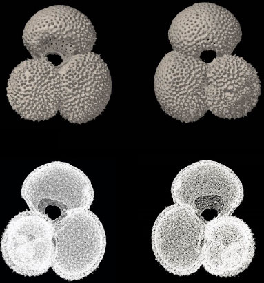
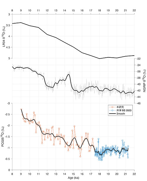
 The Kuroshio is a warm subtropical current that flows from the waters east of the Philippine Sea through the waters east of Taiwan and eastwards through the Okinawa Trough on the western side of the Ryukyu Arc. It circulates clockwise from low to mid latitudes in the western North Pacific and flows out to the Pacific Ocean through the Tokara Strait between southern Kyushu and the northern Ryukyu Archipelago in the waters around Japan. The Kuroshio has a significant impact on the Sea of Japan: economically, it forms one of the world's three major fishing grounds off the Sanriku coast of the Tohoku region; meteorologically, part of the Kuroshio flows as the Tsushima Current to the Sea of Japan side, forming moist air and causing increased rainfall. In view of the above, the aim of this joint research is to consider the impact on modern Japan and the future by clarifying the past changes in the Kurils. In this study, planktonic foraminifera Globigerinoides ruber albus, picked from core samples of KS-22-4 PC02, were used for oxygen isotope ratio measurements to improve the resolution of previous studies and to reconstruct the East China Sea. The resolution was increased to 1-cm in the upper portion of the core, allowing to better resolve global climate excursions during the last deglaciation.
Keywords: oxygen isotope analysis, East China Sea, deglaciation
Automated sediment core image segmentation and length estimations
Sho Isawa, 2024
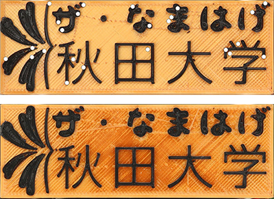 In recent years, quantitative data have been extracted from sediment core images. However, before the data extracted from core images can be compared with other high-resolution data, it is necessary to accurately crop the core images at the top and bottom. This study proposes accurate cropping methods for sediment core images, utilizing both computer vision and deep learning. In computer vision, two types of template images — visually rich targets (core bottom targets) and visually identical scale bars and core bottom targets — are used to match features and crop the core images. Accurate cropping was achieved for images captured by "The Namahage". Deep learning involved training networks using primarily core images provided by the International Ocean Discovery Program (IODP) and performing segmentation to separate the core portion from the rest. Performance was low for data significantly different from the data the networks were trained on, primarily images captured by "The Namahage". Excluding core images captured by "The Namahage" from the training data may lead to higher accuracy results.
Keywords: Semantic segmentation, deep learning, core images
East China Sea Climate Change reconstructed with oxygen isotopes
Soma Sato, 2024
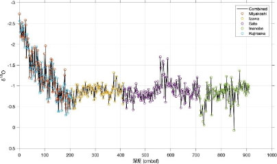
 When the Kuroshio is strong, the Tsushima Current carries large amounts of heat and salt through the Sea of Japan. Variations in the Kuroshio significant impacts Japan’s climate and economy (e.g., fisheries). Therefore, it is necessary to understand past changes in Kuroshio strength to better predict future changes. In this study, oxygen isotope ratios of planktic foraminifers were measured on sediment core samples from Cruise KS-22-4 of the Shinsei Maru to reconstruct paleoenvironmental conditions in the East China Sea. Between this study and previous work, analyses have been completed over the past 24,000 years. During the last glacial, D-O Events were recorded as rapid oxygen isotope variations. Then, during the last glacial maximum at around 20 ka, oxygen isotope ratios were relatively stable. This variability is representative of the Northern Hemisphere in general. In future studies, we plan to increase the number of samples from last deglaciation and Holocene and measure Mg/Ca to reconstruct the sea surface temperature.
Keywords: Kuroshio, Okinawa Trough, oxygen isotope ratio, D-O Event
Paleoceanography of the East China Sea during the Last Glacial Maximum as recorded in planktic foraminifer stable isotopes
Seira Izawa, 2023
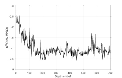
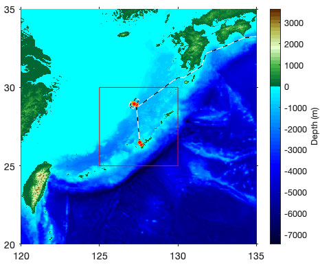 The Kuroshio Current is the western boundary current of the North Pacific subtropical circulation that flows northeastward through the Okinawa Trough in the East China Sea between Taiwan and the southern part of the Nansei Islands and exits into the Pacific Ocean from the Tokara Strait. Fluctuations in the Kuroshio Current have a significant impact on both the climate and fisheries throughout Japan. This study uses a the central portion of a piston core (PC02) from Cruise KS-22-4 of the Shinsei Maru to reconstruct the past paleoceanography of the East China Sea using planktic foraminifer stable isotope ratios.While the ultimate goal of this research is to reconstruct isothermal gradients in the Okinawa Trough during the last glacial period, this research focused on establishing the basic stratigraphic information of the analyzed piston core. Using a combitatin of radiocarbon dating and correlation to a nearby sediment core, a preliminary age model was constructed. Based on this agemodel and variations in oxygen isotope data, the sediment core records a stable environment before and after the last glacial maximum.
Keywords: Kuroshio, oxygen isotope ratio, carbon isotope ratio, Globigerinoides ruber albus, age model
The last deglaciation in the East China Sea as recorded in planktic foraminiferal stable isotopes
Yuri Miyakoshi, 2023
 The Kuroshio Current is the western boundary current of the North Pacific Ocean. It flows from the south of Japan through the Okinawa Trough and along the Japanese coast. The Kuroshio has a significant impact on Japanese society and climate through heat and moisture tranpsort, as well as large scale meanders. The ultimate purpose of this joint research is to consider the impact of the Kuroshio current changes on Japan by clarifying the current changes of the Kuroshio. This study was specifically conducted to establish a stratigraphic framework as a first step to understanding when and under what conditions the sediment cores were deposited from the core samples in the East China Sea. The upper porition of piston core PC02 (obtained during Cruise KS-22-4 of the Shinei Maru) was analyzed. Oxygen isotope ratios record decreasing value and several fluctuations correponsing to the last deglaciation and climate variability. There is also evidence of limited erosion caused by the Kuroshio Current.
Keywords: Kuroshio Current, Okinawa Trough, tidal current variation, oxygen isotope ratio, climate change
Identification of Tsunami Deposits in Isumi River lowland, central Boso Peninsula, Japan
Soichiro Oda, 2022
 The Boso Peninsula, Chiba Prefecture, is a region that is repeatedly affected by trench earthquakes and tsunamis generated at the plate boundaries associated with the Sagami Trough and the Japan Trench. Following the Tohoku-Pacific Ocean earthquake and resulting tsunami in 2011, effort to understand past Kanto earthquakes increased substantially, and a number of boreholes were drilled for research.
This study uses borehole material from the Isumi River lowland to assess the timing and extent of prehistorical tsunami occurrence in the eastern Boso Peninsula. A number of coarse event layers are recognized, but careful consideration is required to distinguish tsunami and storm deposits. Through comprehensive sedimentologic interpretation, multipoint radiocarbon dating, and high-resolution elemental analyses, multiple tsunami deposits are identified.
Keywords: Tsunami deposit, Sagami Trough, Boso Peninsula, Kanto earthquake, Paleoenvironmental reconstruction, Radiocarbon dating
Identification of tsunami deposit in Tateyama lowland on the southwest coast of the Boso Peninsula from past Kanto earthquakes
Yoshiya Hatakeyama, 2022
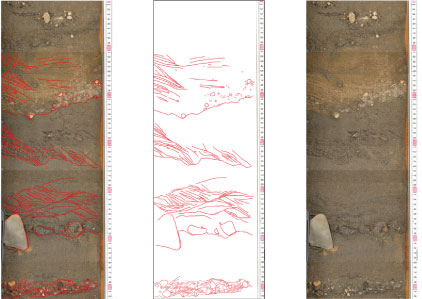 This study compares the historical record of Kanto earthquakes to the sedimentary record of event deposits in the Tateyama lowland of the Boso Peninsula to improve past estimates of recent tsunami occurrence. A major defining characteristic of a tsunami deposit, distinguishing it from a storm layer, is multiple-layered structure recording repeated wave run-up and backwash. However, a typical borehole is too narrow to observe sedimentary structures at a scale that allows determination of current direction.
Therefore, a device known as a “geoslicer” sampled wide, directionally oriented, continuous sediment sections from below ground. Sedimentary structures such as cross bedding and current ripples are interpreted to infer current direction. The structure of the CE1703 Genroku Tsunami is considered and compared to that of deeper event deposits. The age of the events exhibiting tsunami-like structure are reconsidered based on the latest radiocarbon calibration and estimate of local reservoir age.
Keywords: Genroku earthquake, Taisho Kanto earthquake, local reservoir effect, multiple-classified stratification, Tateyama lowland, formation interval
Understanding the Mid Pleistocene to Holocene sedimentary systems of the Great Barrier Reef region in Northeastern Australia
Takumi Asada, 2020
 The Great Barrier Reef (GBR) is a large reef system adjacent to a subtropical rainforest in Northeast Australia. Due to modern global warming, the GBR is experiencing significant bleaching, but the observational record of natural reef fluctuations is relatively short. It is therefore necessary to understand the longer history of reef development.
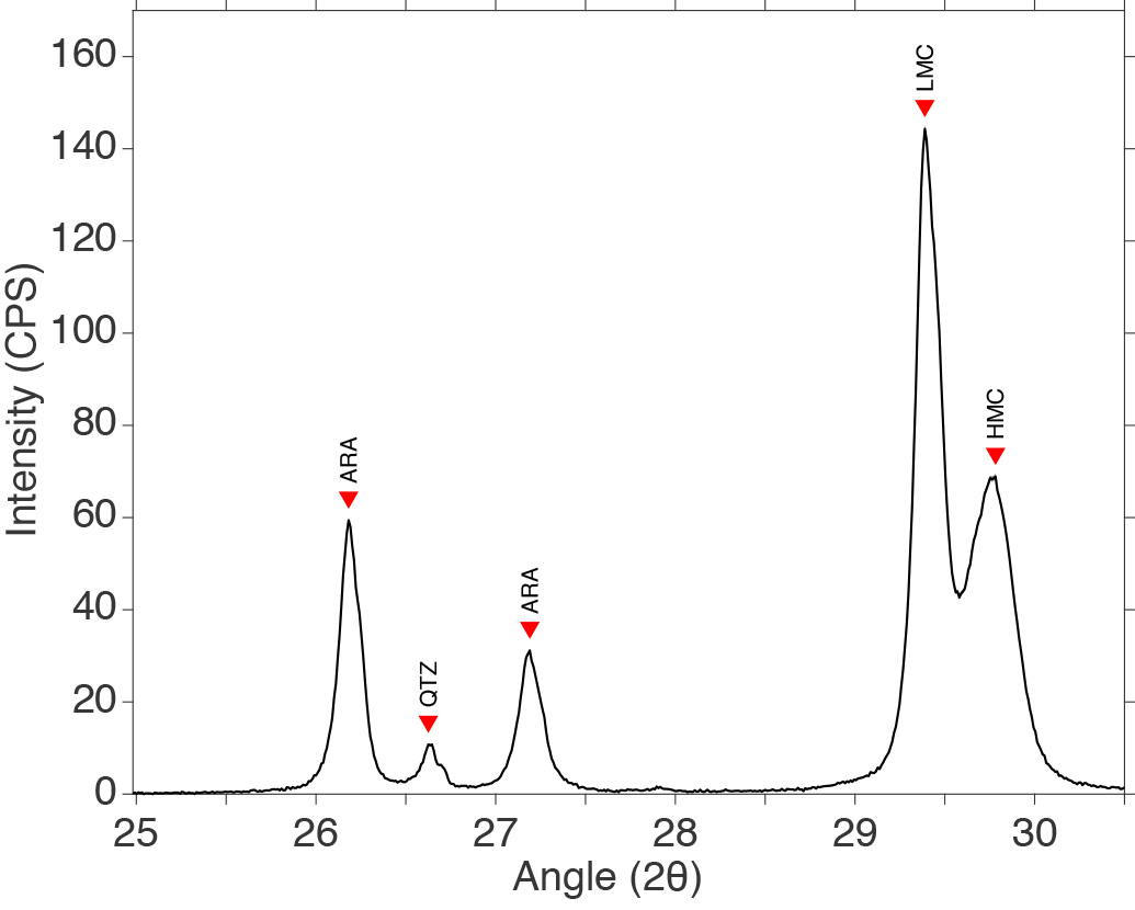
Previous research (Miwa, 2018 BS) measured oxygen isotopes and the percentage of sediment derived from land (terrigenous sediment) to estimate that the GBR was formed approximately 850,000 years ago. However, the percentage of terrigenous sediment could vary due to precipitation changes altering river discharge. Therefore in this study, X-ray diffraction (XRD) was used to determine the amount of varying marine sediment components, the percentage of which is unaffected by precipitation amount, to re-evaluate the estimated age of the GBR. Results show similar variations as terrestrial sediment, support the previously estimated age of the GBR.
Keywords: Barrier reef, Sea level transgressions, Age model, High Magnesium Calcite, Mass accumulation rate
Determining the Age of the Great Barrier Reef through sedimentary facies analysis
Wataru Miwa, 2018
 The Great Barrier Reef (GBR) forms a rim along the Northeast Australian coast and is the world’s largest reef system. While there has been a number of studies of the GBR, due to a number of complicating factors, it is difficult to directly determine its age. Therefore, this study used material from Hole 1198A, a borehole from Ocean Drilling Program Leg 194, to indirectly assess the age of the GBR. This was done using planktic foraminifers to estimate geologic age and sea level change while tracking changes in the sedimentary components deposited seaward of the reef. Results indicate that an effective barrier was formed along the continental shelf by around 850,000 years ago. Recent global warming has put the world’s reef in danger. Therefore it is important to understand the context of the changes happening to today’s reefs by studying their past history.
Keywords: Oxygen isotope ratio, Marine Oxygen Isotope stage, eustasy, Barrier reef, Mass accumulation rate,
Graduate Theses
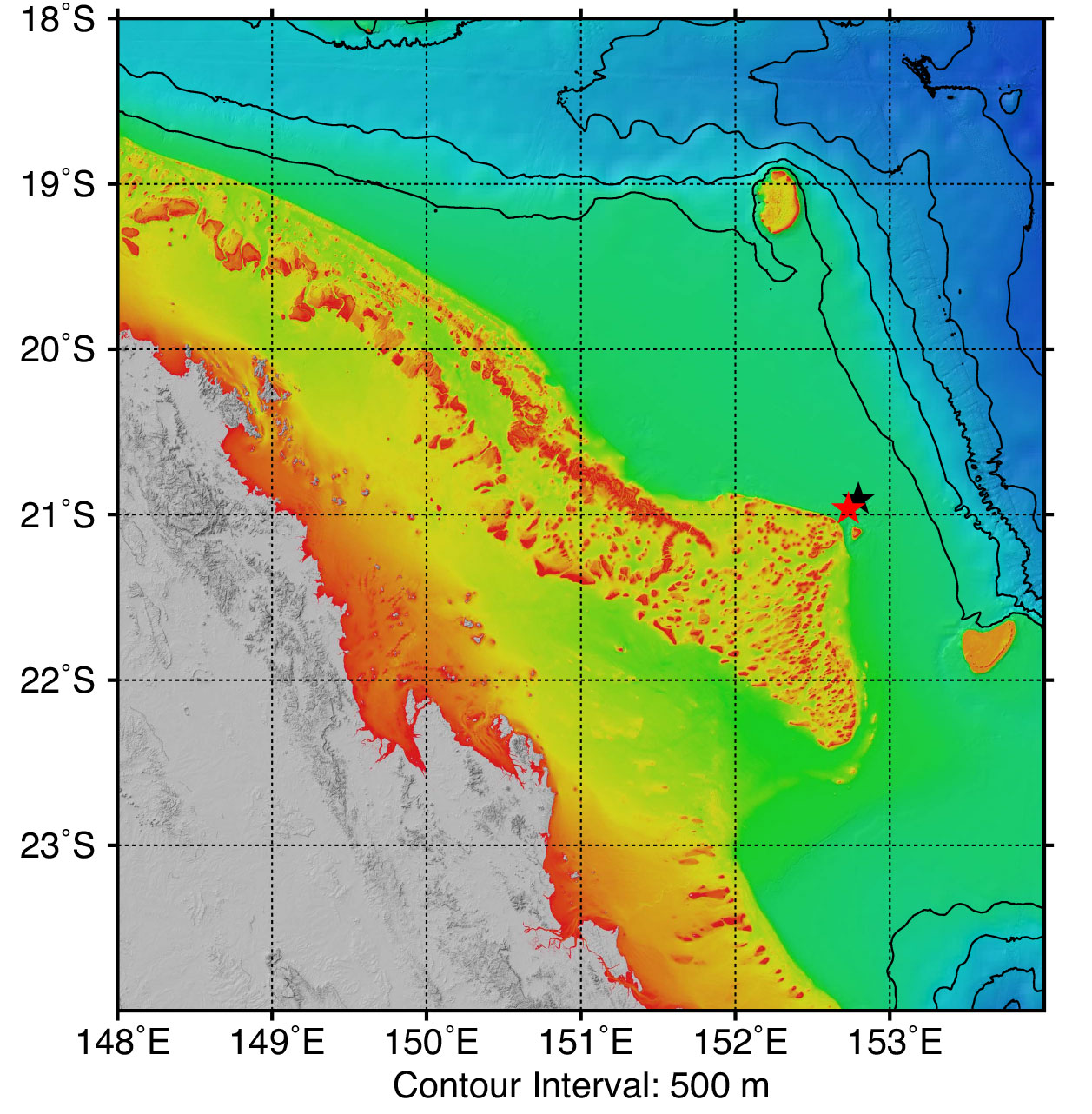
Bottom-Water Variability in the Okinawa Trough during the Last Glacial Maximum: Insights from Mg/Ca and stable isotope of Uvigerina peregrina
Rizkysafira Ishendriati, 2025 MS
 Understanding the variability of bottom-water conditions during glacial periods is essential for reconstructing past ocean circulation and climate dynamics. The Okinawa Trough, situated at the margin of the subtropical North Pacific, represents a key location for studying intermediate-to-deep water mass evolution under glacial-interglacial cycles. However, previous research has predominantly focused on surface hydrography or the Kuroshio Current path, leaving the history of bottom-water properties largely unconstrained. This study makes an important contribution by focusing specifically on bottom-water variability during the Last Glacial Maximum (LGM; ~24-17 ka BP), using multiproxy geochemical records from piston core PC02. By targeting a critical knowledge gap in marginal basin paleoceanography, this work provides new and exciting insights into the hydrographic evolution of the middle Okinawa Trough.
Keywords: Oxygen isotope ratios, bottom water temperature, water mass properties, benthic foraminifera
Reconstructing Subsurface Ocean Conditions in the Okinawa Trough Over the Past 25,000 Years Using Benthic Foraminiferal δ18O and Mg/Ca Records
Anjalia Wardani, 2025 MS
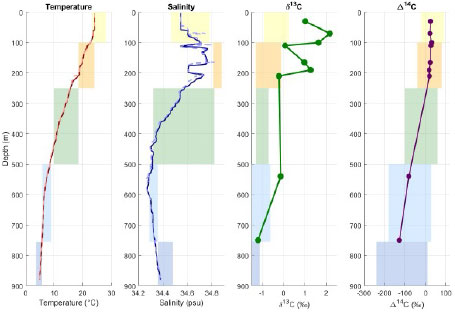
 This study investigates subsurface oceanographic variability in the Okinawa Trough over the past 25,000 years, with a focus on reconstructing Bottom Water Temperature (BWT), seawater δ¹⁸O (δ¹⁸Osw), and δ¹³C gradients using benthic foraminifera (Uvigerina peregrina). The results show that BWT remained relatively stable throughout the Holocene and deglacial periods, with a slight, non-significant decrease toward the Holocene. δ18Osw exhibited cyclic variations between 10 and 12 ka, which are interpreted as a response to the weakening of the Atlantic Meridional Overturning Circulation (AMOC), influencing salinity and surface temperatures. The δ13C gradient increased from ~1.5‰ during the Last Glacial Maximum (LGM) to ~2.5‰ during the Holocene, reflecting changes in water mass properties, stratification, and deep-water ventilation. Holocene sea-level rise led to reduced mud input and increased coarse and biogenic sedimentation, with a positive correlation between foraminiferal abundance and coarse sediment fractions. These findings highlight the influence of sea-level changes and provide insights into subsurface oceanographic conditions, enhancing our understanding of vertical water mass dynamics in the Okinawa Trough during periods of climate variability.
Keywords: Oxygen isotope ratios, bottom water temperature, water mass properties, benthic foraminifera
Reconstruction of the fire and vegetation change history of the Kapuas Wetlands, Indonesia
Aulia Patria, 2024 MS
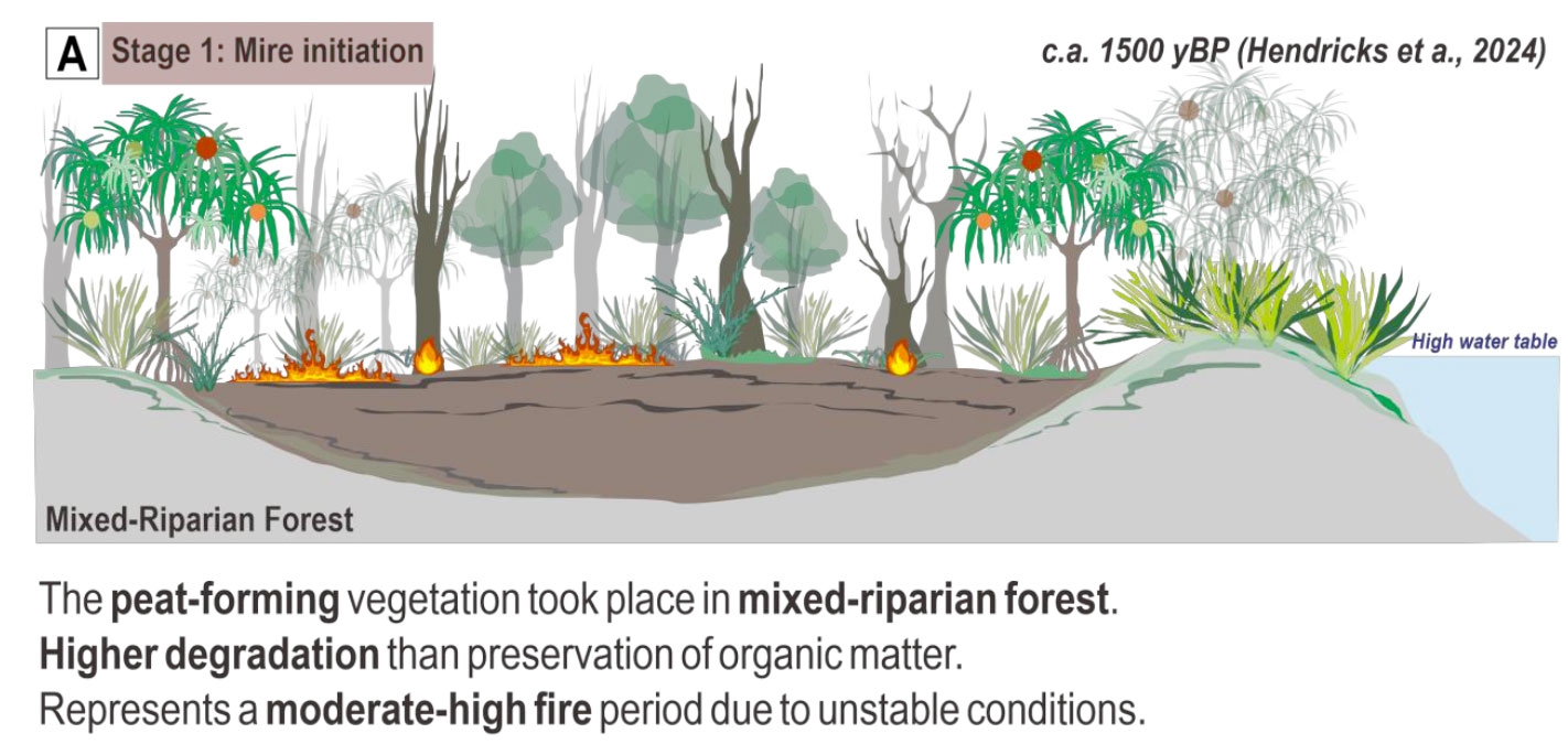 Peatlands are believed to be important as significant long-term global carbon sinks of atmospheric carbon dioxide. As the climate continues to change globally, it is expected that all aspects of the fire regime, including severity, will display immediate responses, increasing future fire impacts on soil, water and vegetation. The ignition of flammable dry peat substrate, either naturally or anthropogenically, may lead to periods of extensive peat fires, the dynamics of which we aim to clarify. This study used stable carbon and nitrogen isotopes, multiple organic proxies, and microcharcoal analyses to identify the characteristics and severity of past fire periods. Sediment layers formed during and after fire events are expected to display distinct carbon and nitrogen isotope signatures due to preferential volatilization during combustion and changes in plant-derived organic inputs with increasing fire severity. Given their high sensitivity to environmental disturbance, peat deposits provide robust archives for palaeoecological reconstruction. This approach is tested on peat deposits from the Kapuas coastal wetlands, West Kalimantan, which have experienced both natural and anthropogenic fire regime.
Keywords: peatlands; carbon and nitrogen isotopes; fire; organic matter
Multiple applications of radiocarbon to environmental research
Soichiro Oda, 2024 MS
 Carbon isotope ratio analysis of seawater by AMS and 14C dating of four piston core samples were conducted to discuss the influence of the Kuroshio Current using the obtained Δ14C-DIC and CTD data observed during the KS-22-4 voyage, and to determine the age-depth model. The Kuroshio Current, which flows northeastward along the shelf slope of the East China Sea, transports heat from low to mid latitudes as a subtropical gyre in the North Pacific Ocean, and the variations in its flow path and discharge affect the climate, aquatic resources, and shipping in the surrounding areas. As a result, the influence of the Kuroshio Current in our study area, located in the central Okinawa Trough, is suggested, and age-depth models of four piston cores are created.
I also examined sandy deposits from core ISL-6, which was collected from a wetland site located on the north bank of the Isumi River lowland in the Boso Peninsula. In addition to identifying event deposits, reconstructing the depositional environment by CNS elemental analysis, and 14C dating, which were conducted as a graduation thesis, this study newly conducted grain size analysis, additional dating, and redefinition of the age-depth model. In the result, we identified that the event sand layers deposited in the core were likely transported by seaward overwash and these sand layers were most likely brought by the tsunami.
Carbon isotope ratio analysis of seawater by AMS and 14C dating of four piston core samples were conducted to discuss the influence of the Kuroshio Current using the obtained Δ14C-DIC and CTD data observed during the KS-22-4 voyage, and to determine the age-depth model. The Kuroshio Current, which flows northeastward along the shelf slope of the East China Sea, transports heat from low to mid latitudes as a subtropical gyre in the North Pacific Ocean, and the variations in its flow path and discharge affect the climate, aquatic resources, and shipping in the surrounding areas. As a result, the influence of the Kuroshio Current in our study area, located in the central Okinawa Trough, is suggested, and age-depth models of four piston cores are created.
I also examined sandy deposits from core ISL-6, which was collected from a wetland site located on the north bank of the Isumi River lowland in the Boso Peninsula. In addition to identifying event deposits, reconstructing the depositional environment by CNS elemental analysis, and 14C dating, which were conducted as a graduation thesis, this study newly conducted grain size analysis, additional dating, and redefinition of the age-depth model. In the result, we identified that the event sand layers deposited in the core were likely transported by seaward overwash and these sand layers were most likely brought by the tsunami.
Keywords: Kuroshio Current, Sea water, planktic foraminifers, radiocarbon, geochronology
Mg/Ca-based Holocene paleotemperature reconstruction in the western region of Okinawa Island and Calibration of color values extracted from “Namahage” core scanner images using spectrophotometry.
Yoshiya Hatakeyama, 2024 MS
 The Kuroshio Current which flows west of the main island of Okinawa is part of the ocean circulation in the high latitudes of the North Pacific. It plays an important role in understanding Japan's fisheries and climate change because of transporting heat and salt. Through oxygen isotope ratio measurements and Mg/Ca measurements, I quantitatively estimated the paleowater temperature in the western part of Okinawa's main island during the Holocene and calculated the oxygen isotope ratio of seawater. After "stabilizing" the brightness and extracting the color values from the image, a correction function is obtained by calibrating it with a spectrophotometer.
The reliability of the correction function obtained was improved and the validity of the color values extracted from the core image was verified.
The Kuroshio Current which flows west of the main island of Okinawa is part of the ocean circulation in the high latitudes of the North Pacific. It plays an important role in understanding Japan's fisheries and climate change because of transporting heat and salt. Through oxygen isotope ratio measurements and Mg/Ca measurements, I quantitatively estimated the paleowater temperature in the western part of Okinawa's main island during the Holocene and calculated the oxygen isotope ratio of seawater. After "stabilizing" the brightness and extracting the color values from the image, a correction function is obtained by calibrating it with a spectrophotometer.
The reliability of the correction function obtained was improved and the validity of the color values extracted from the core image was verified.
Keywords: Kuroshio Current, Benthic foraminifera, BWT, Holocene, Mg/Ca, Oxygen isotope ratio, Stabilization, Spectrophotometry, The Namahage, RGB, LAB, Regression line
Elucidation of the sedimentary system of Northeastern Australian continental margin to determine the age of formation of the Great Barrier Reef.
Takumi Asada, 2022 MS
 Miwa (2018 BS) determined the age of the Great Barrier Reef (GBR) but didn’t address the reasons that it formed. One way of doing that is by reconstructing the environmental changes that happened before, during, and after its formation, which can be accomplished by measuring the trace element Mg in the tests of fossil planktic foraminifers to track changes in sea surface temperature. However, there is a dearth of such data measured from the study area, so it is unclear what challenges will be encountered.
To that end, this study worked to develop a method for applying Mg/Ca paleothermometry to the shallow sediments from the study area using facilities at the University of Tokyo Atmosphere and Ocean Research Institute. It was found that the foraminifers deposited there contain significant secondary minerals that are resistant to cleaning procedures and contaminate the temperature signal. By exploring concentrations of other trace elements, this study proposed methods to correct for this contamination and suggested a number of ways for successfully applying Mg/Ca paleothermometry to sediments from this region.
Keywords: Mg/Ca, paleothermometer, foraminifera, Great Barrier Reef, diagenesis
Development of a Mg/Ca paleothermometry method applicable to planktonic foraminifers in a shallow-slope environment of Northeast Australia (ODP Site 1198).
Wataru Miwa, 2020 MS
 Miwa (2018 BS) determined the age of the Great Barrier Reef (GBR) but didn’t address the reasons that it formed. One way of doing that is by reconstructing the environmental changes that happened before, during, and after its formation, which can be accomplished by measuring the trace element Mg in the tests of fossil planktic foraminifers to track changes in sea surface temperature. However, there is a dearth of such data measured from the study area, so it is unclear what challenges will be encountered.
To that end, this study worked to develop a method for applying Mg/Ca paleothermometry to the shallow sediments from the study area using facilities at the University of Tokyo Atmosphere and Ocean Research Institute. It was found that the foraminifers deposited there contain significant secondary minerals that are resistant to cleaning procedures and contaminate the temperature signal. By exploring concentrations of other trace elements, this study proposed methods to correct for this contamination and suggested a number of ways for successfully applying Mg/Ca paleothermometry to sediments from this region.
Keywords: Mg/Ca, paleothermometer, foraminifera, Great Barrier Reef, diagenesis