Environmental Geoinformatics Laboratory
Research
Research
Recent and ongoing projects
We are utilizing high-resolution geological archives to clarify the processes driving environmental change. We are applying fundamentals of stratigraphy, sedimentology, paleoceanography, paleoclimatology, geochronology, and data science to answer outstanding questions on multiple timescales, from the most recent several hundred years to the past several million years.
We are actively developing both hardware and software tools to realize these research goals. Examples include geochronological tools for modeling geologic age while considering uncertainty, a means for detecting and correcting non-linear sediment deformation, and a portable, inexpensive sediment core scanner. The latter uses computer vision and deep learning techniques to acquire and post-process images, producing high-quality images at a fraction of the cost of a traditional (and fragile) linescanner.
Past Kuroshio Variability
 The Kuroshio transports heat and moisture northward into both the Sea of Japan and Pacific Ocean. Variations in the path and strength strongly affect the climate and economy of Japan. However, past changes in the Kuroshio have yet to be quantitatively reconstructed. Better understanding the past long-term variability of the Kuroshio will help to predict future changes.
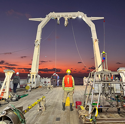
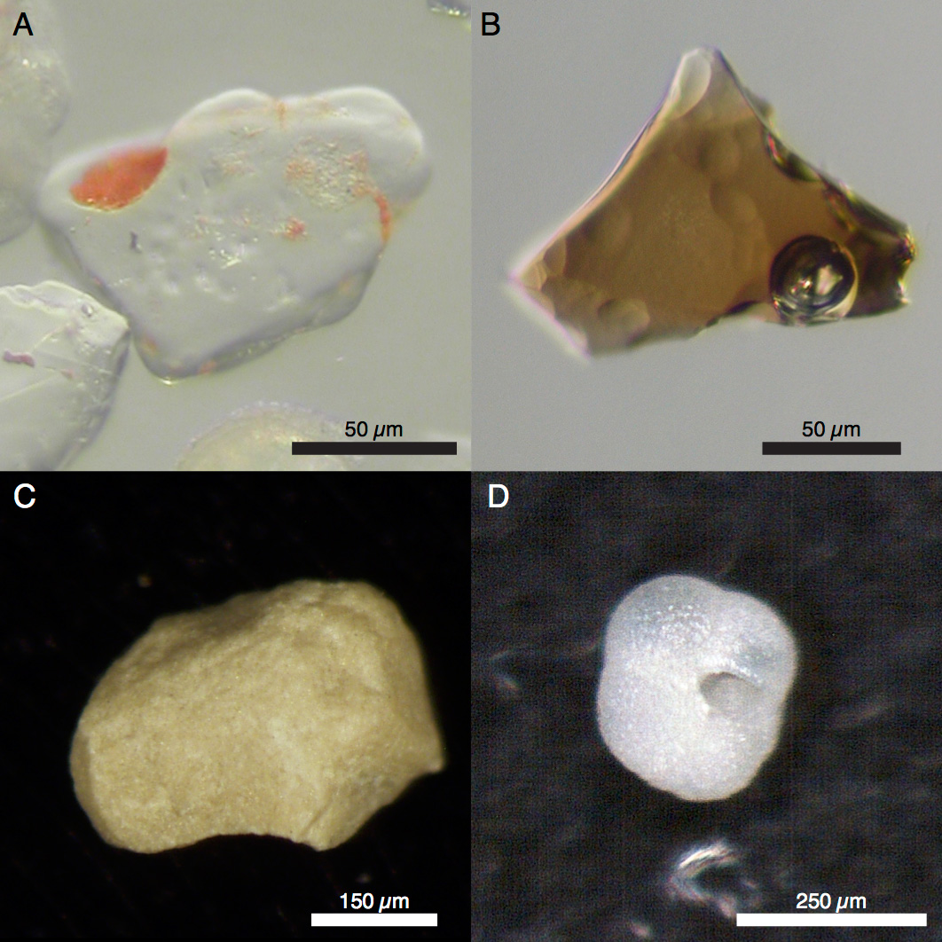
Led by the National Museum of Nature and Science, we are part of a large team working to understand past chnages in the Kuroshio by reconstructing water temperature gradients across the current, which are directly controlled by current strength. This is being done through a number of research cruises to the Okinawa Trough, including KS-22-4 and KH-23-11. Using benthic foraminifers in sediment cores on the eastern and western slopes of the trough provide bottom temperature estimates at similar depths in the past. In turn, this will clarify temperature gradients, allowing consideration of current strength.
Origin of the Great Barrier Reef
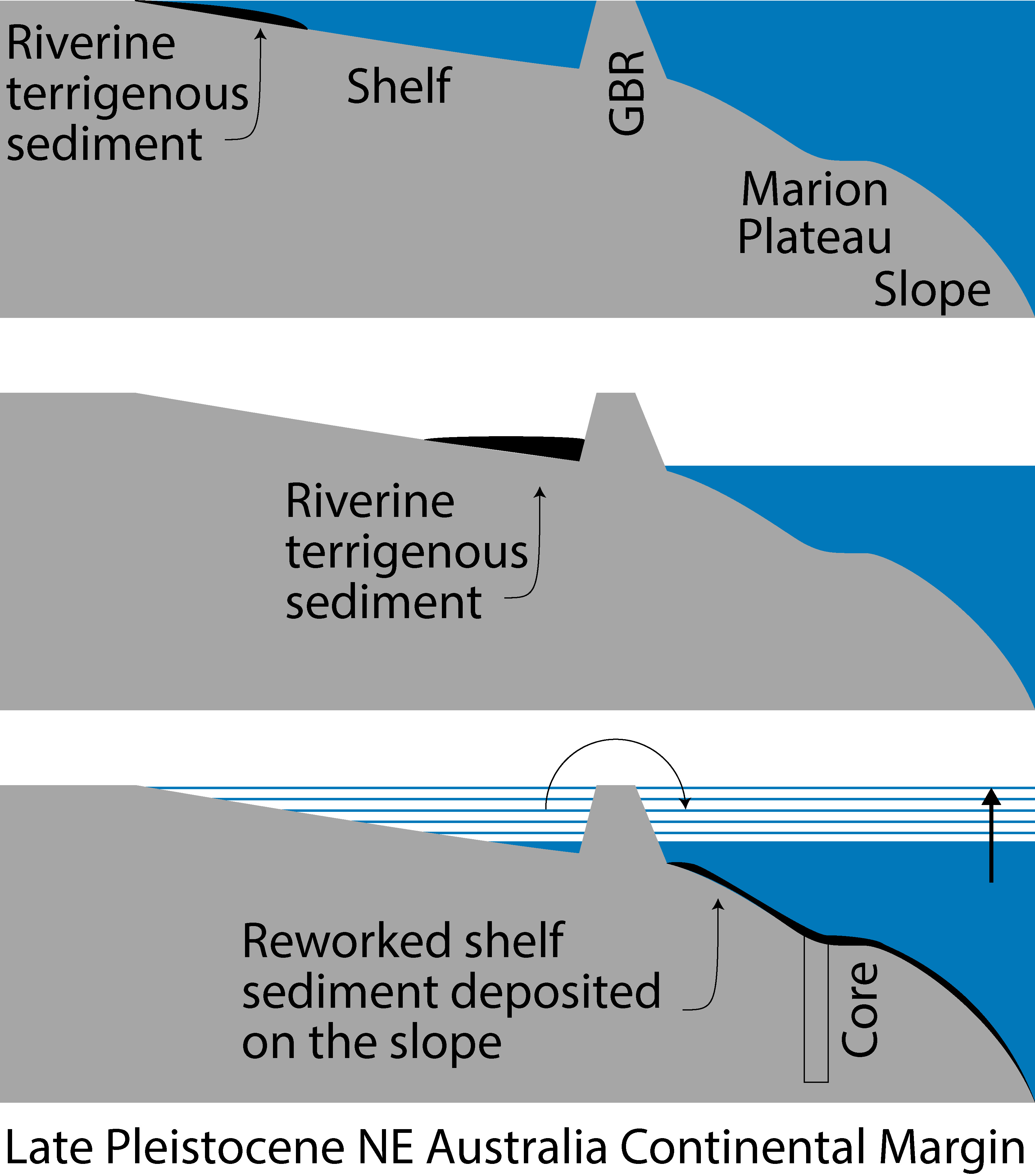 Determining the age of the Australian Great Barrier Reef (GBR) is complicated by the lack of appropriate absolute age dating methods. We are leveraging the unique setting of the GBR region, which is characterized by a highly-productive carbonate factory adjacent to a monsoon-dominated tropical forest with rivers that discharge a substantial volume of terrigenous sediment, to indirectly constrain the age of the GBR. This allows us to use sedimentological principals to reconstruct the geomorphologic evolution of the continental shelf to understand when a barrier formed.
Using a spliced, multiproxy record from ODP Hole 1198A and GeoB22218-1, each recovered from the Marion Plateau (~350 mbsl), seaward of the shelf break, we determined that the GBR is likely 750,000 to 800,000 years old.
We are also investigating whether the formation of a barrier reef was coincident with significant environmental change by analyzing micro- and nano-fossil assemblages and planktic foraminifer trace-element geochemistry. Was the formation of a barrier reef simply related to the increasing length of periods of high sea level, or was there an environmental trigger.
Obrochta, S.P., Miwa, W., Shirai, K., Kubota, K., Yokoyama, Y., Miyairi, Y., Asada, T., Webster, J., Mohtadi, M., and Hine, A.C., 2019. Mid Pleistocene Age for the Great Barrier Reef. American Geophysical Union Fall Meeting.
Related:
Webster, J.M., Braga, J.C., Humblet, M., Potts, D.C., Iryu, Y., Yokoyama, Y., Fujita, K., Bourillot, R., Esat, T.M., Fallon, S., Thompson, W.G., Thomas, A.L., Kan, H., McGregor, H.V., Hinestrosa, G., Obrochta, S.P., and Lougheed, B.C., 2018. Response of the Great Barrier Reef to sea-level and environmental changes over the past 30,000 years. Nature Geoscience 11, 426–432. 10.1038/s41561-018-0127-3
Sanborn, K.L., Webster, J.M., Webb, G.E., Braga, J.C., Humblet, M., Nothdurft, L., Patterson, M.A., Dechnik, B., Warner, S., Graham, T., Murphy, R.J., Yokoyama, Y., Obrochta, S.P., Zhao, J., and Salas-Saavedra, M., 2020. A new model of Holocene reef initiation and growth in response to sea-level rise on the Southern Great Barrier Reef. Sedimentary Geology 397. 10.1016/j.sedgeo.2019.105556
Student Theses
Miwa W., 2018 BS. Determining the Age of the Great Barrier Reef through sedimentary facies analysis
Asada, T., 2020 BS. Understanding the Mid Pleistocene to Holocene sedimentary systems of the Great Barrier Reef region in Northeastern Australia
Miwa, W., 2020 MS. Development of a Mg/Ca paleothermometry method applicable to planktonic foraminifers in a shallow-slope environment of Northeast Australia (ODP Site 1198)
Asada, T., 2022 MS. Elucidation of the sedimentary system of Northeastern Australian continental margin to determine the age of formation of the Great Barrier Reef
Mt Fuji Holocene Eruption History and Monsoon Reconstruction
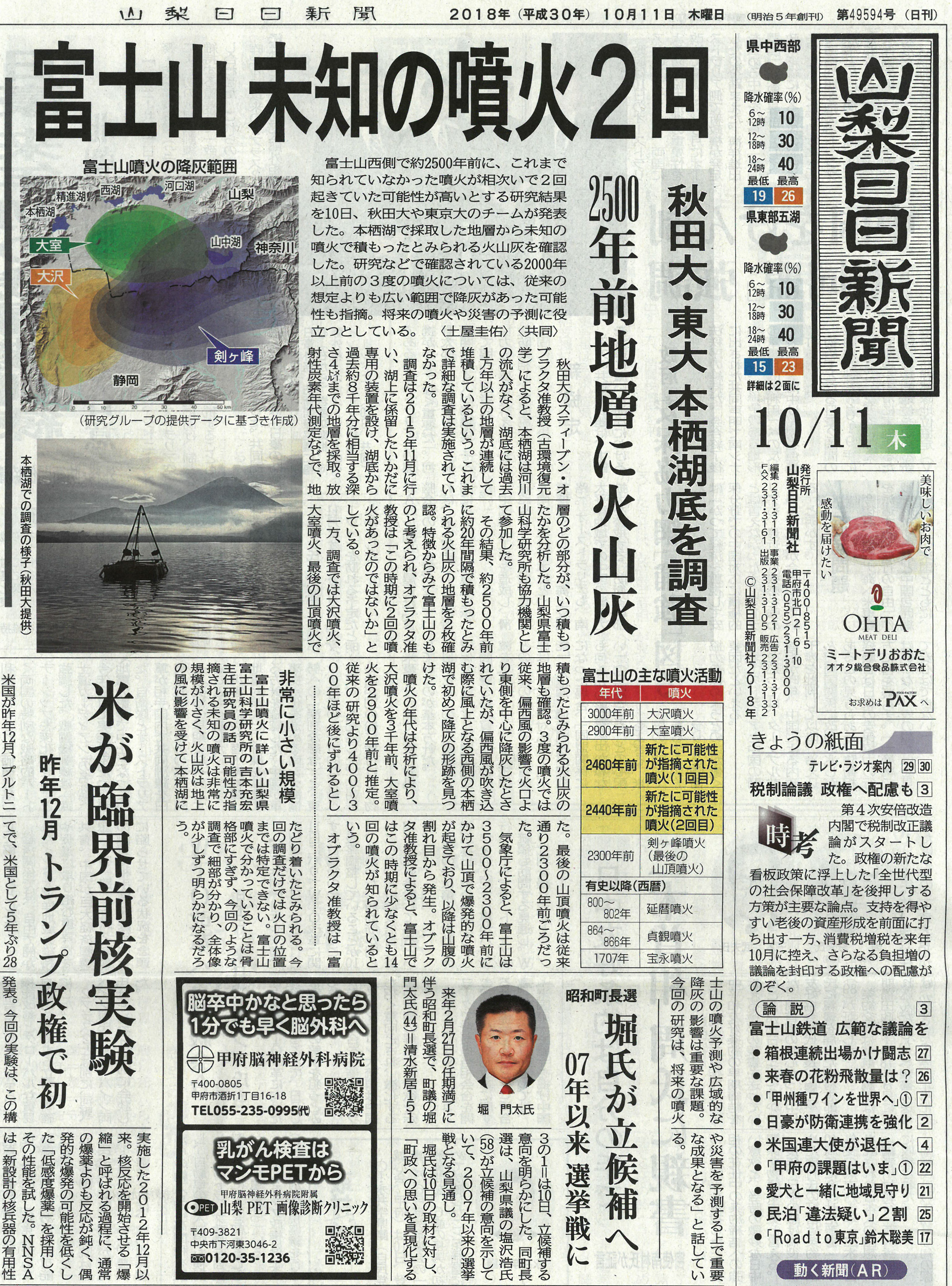 Mt. Fuji is an active volcano and a UNESCO World Heritage site with over 47 million annual visitors to the region. Evaluating the potential of a future eruption and the scope of the affected area requires information about past eruptive activity. To date, this information was available only through land-based studies, which may neither provide a continuous record nor the best material for determination of the age of past eruptions. To overcome these issues, we studied continuously-accumulating sedimentary layers retrieved by sediment coring from below the floor of Lake Motosu, one of the Fuji Five Lakes, obtaining a much clearer picture of the timing of eruptions and the extent of the affected area.
We identified layers of volcanic ash (known as scoria) preserved in Lake Motosu sediments that were deposited by the Osawa, Omuro, and Kengamine eruptions, as well as two previously undetected eruptions. Several dozen radiocarbon measurements were performed and, along with the ages of two other known eruptions (of different volcanos, not Mt. Fuji), an extremely precise age-depth model was created to determine the age of the sampled material. We then revised the estimated ages of the three known eruptions, which were previously not believed to have dispersed ash this widely.
We are also currently working on reconstructing monsoon precipitation using oxygen isotope ratios of aquatic cellulose with Jon Tyler of Adelaide University, Australia.
Obrochta, S.P., Yokoyama, Y., Yoshimoto, M., Yamamoto, S., Miyairi, Y., Nagano, G., Nakamura, A., Tsunematsu, K., Lamair, L., Hubert-Ferrari, A., Lougheed, B.C., Hokanishi, A., Yasuda, A., Heyvaert, V.M.A., De Batist, M., and Fujiwara, O., 2018. Mt. Fuji Holocene eruption history reconstructed from proximal lake sediments and high-density radiocarbon dating. Quaternary Science Reviews 200, 395–405. 10.1016/j.quascirev.2018.09.001
Obrochta, S.P., 藤原 治., 横山 祐典, and 宮入 陽介, 2019. 本栖湖の湖底堆積物の精密な放射性炭素 年代測定が明らかにする富士山の噴火史. Isotope News 763, 22–25. (PDF)
藤原 治, Obrochta, S.P., 横山 祐典, 宮入 陽介, and 常松 佳恵, 2019. 湖底堆積物から探る富士山の噴火史 -本栖湖に残されていた未知の噴火の発見-. GSJ 地質ニュース 8(3) 66–69. (PDF)
Geochronology and Age Modeling
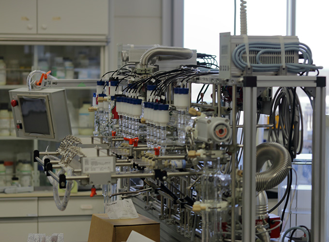
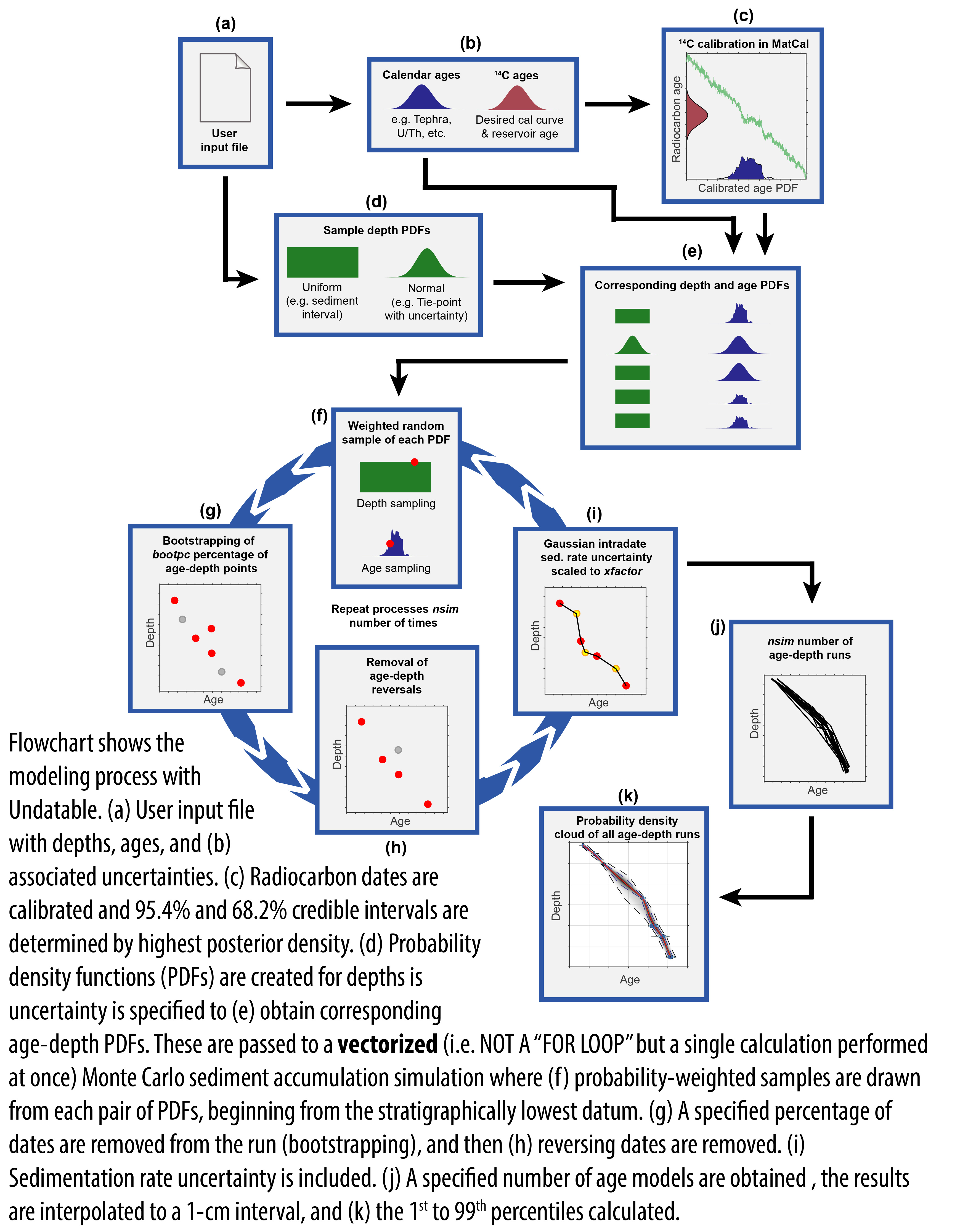 Traditional approaches to age-depth modelling typically assume no uncertainty for the depth value of dated intervals. However, such an assumption may not be fully valid in the case of poor coring recovery or significant sediment deformation, as well as in the case of a large subsampling interval. In consideration of these issues, we developed a new age-depth modelling routine, Undatable, which includes uncertainty in both age and depth. Undatable uses Bayesian radiocarbon calibration software (MatCal) and a deterministic approach with a positive sediment accumulation rate (SAR) assumed a priori which, combined with efficient programming practices, allows for the rapid production (in a matter of seconds in many cases) of age-depth models for multiple types of geological archives. Undatable has so far been successfully applied to coral archives, as well as sediment archives from estuarine, lacustrine and deep-sea environments. Through the inclusion of a bootstrapping option, the software performs particularly well in the case of a large scatter in age-depth constraints by expanding the uncertainty envelope of the age-depth model. Unlike other deterministic models, increasing the density of age-depth constraints results in increased precision in Undatable, even at centennial scale, thus emulating the results of probabilistic models.
Learn more about Undatable and download
Lougheed, B.C., and Obrochta, S.P., 2019. A Rapid, Deterministic Age-Depth Modeling Routine for Geological Sequences With Inherent Depth Uncertainty. Paleoceanography and Paleoclimatology 34(1) 122–133. 10.1029/2018PA003457
Deep Learning for Sediment Core Interpretation
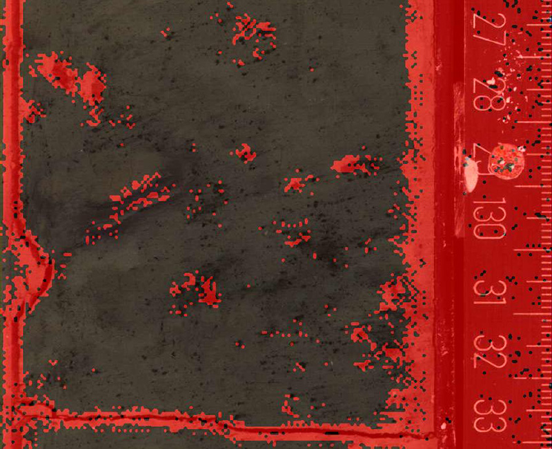 As a first step in building a toolkit for the computer analysis of images of sea floor sediment cores, we developed a technique to automate the time-consuming manual identification, interpretation, and exclusion of disturbed regions of the cores. The retrieved cores contain artifacts, e.g., induced by the extraction itself, that should be ignored to improve the efficiency of environmental reconstruction. From a computer vision perspective, the task of identifying those artifacts is an image segmentation problem. The method we describe as a solution uses the recently introduced fully convolutional neural networks (FCN), which have been shown to be very efficient in segmenting images.
We have further trained FCNs to identify layers with visible biological disturbance, so-called bioturbation. Similar to the extraction-induced disturbance described above, bioturbation is a post depositional process that alters, for example, the original fabric, texture and color of sediment. This allows us to more efficiently consider the more pristine regions when evaluating apparent environmental changes.
We are also exploring a means for this work to supplement existing models of bioturbation for site-specific application to age-depth modeling. In particular, this will allow us to develop better informed assumptions (e.g., Bayesian prior distributions) regarding the amount of post-depositional sediment mixing and hence the degree of chronostratigraphic uncertainty.
Fazekas, S.Z., Isawa, S., and Obrochta, S.P., 2023. Automated Extraction of Sediment Core and Scale Segments from Core Scanner Images. 2023 15th International Conference on Information Technology and Electrical Engineering (ICITEE) 1–6. 10.1109/ICITEE59582.2023.10317723
Fazekas, S.Z., Obrochta, S.P., Sato, T., and Yamamura, A., 2017. Segmentation of coring images using fully convolutional neural networks. 2017 9th International Conference on Information Technology and Electrical Engineering (ICITEE) 1–5. 10.1109/ICITEED.2017.8250490
Student Thesis
Isawa, S., 2024 BS. Automated sediment core image segmentation and length estimations
The Namahage - a Portable System for Acquisition of Low-distortion Core Images
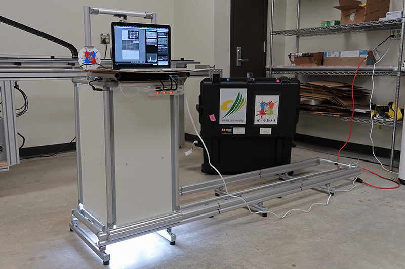 While imaging the split surface of sediment cores is standard procedure across a range of geoscience fields, obtaining high-resolution, continuous images with very little distortion has traditionally required line-scanning systems. These devices require exacting movement of a camera that in turn must rapidly capture frames at a precise time interval. Thus this equipment is expensive, fragile, typically installed only in specialized facilities and research vessels, and not easily transported into the field or onto general-purpose ships. Because several tens of centimeters below the sea or lakefloor is usually devoid of oxygen, sediment cores often begin to rapidly change color after retrieval due to oxidation, necessitating immediate imaging. Researchers may not be able to wait to bring the sediment cores to a specialized facility, and thus take photographs of entire core sections, which may result in distortion, particularly at the upper and lower edges.
To overcome this issue, in collaboration with Takeshi Nakagawa of Ritusmeikan University, we constructed an inexpensive, portable, rigid, manually-actuated camera sliding frame to take a series of overlapping photographs of a split sediment core. We then developed a set of open source tools for seamlessly stitching together the photographs using computer vision techniques. The resulting composite image contains less distortion than a single photograph of the entire core section. The method allows for detection of and correction for variable camera tilt and rotation between adjacent pairs of images.
In addition to the fully convolutional neural networks (described in the previous section) for identifying regions of physical and biological disturbance, we are also developing networks to post-process the image to automate the tedious task of segmenting the sediment core from the background, while also detecting the location of the accompanying scale bar and (in the future) automatically determining the length of the core.
We are thus working to produce a hardware-software solution to obtain the high-quality images needed for age-depth modeling and environmental evaluation research.
Obrochta, S.P., Fazekas, S.Z., Moren, J., 2022. Acquisition and processing of low-distortion sediment core images with computer vision and deep learning. AGU Fall Meeting 2022
Obrochta, S.P., Fazekas, S.Z., Moren, J., 2020. A portable system for acquisition of low-distortion sediment core images using computer vision and deep learning for post-processing. Japan Geoscience JpGU – AGU Joint Meeting 2020 (online)
Obrochta, S.P., Fazekas, S.Z., Moren, J., 2020. Using computer vision and deep learning for acquisition and processing of low-distortion sediment core images. European Geosciences Union General Assembly 2020 (online)
Student Thesis
Hatakeyama, Y. 2024. Mg/Ca-based Holocene paleotemperature reconstruction in the western region of Okinawa Island and Calibration of color values extracted from “Namahage” core scanner images using spectrophotometry.
Geohazards: Tokai/Nankai Earthquake Recurrence
 Together with collaborators, we discovered traces of late 7th and 9th century Tokai Earthquakes in Western Shizuoka Prefecture. This clarified and documented the connection between Tokai and Nankai Earthquakes over the past 1300 years. While Nankai earthquakes in 684 CE and 887 CE are documented, it was previously unknown if corresponding Tokai Earthquakes occurred. Historical document indicate that the 887 CE earthquake in particular caused shaking over an extremely wide area, and the new discovery of tsunami deposits in Western Shizuoka confirms that a corresponding Tokai Earthquake also occurred. Because each tsunami transported and redistributed organic material, this complicated determination of the age of the earthquakes. Therefore, the Environmental Geoinformatics Laboratory applied state of the art methods to find the most probably age of the tsunami deposits. Results of this research indicate that, on geological time scales, Tokai and Nankai Earthquakes are related.
Fujiwara, O., Aoshima, A., Irizuki, T., Ono, E., Obrochta, S.P., Sampei, Y., Sato, Y., and Takahashi, A., 2020. Tsunami deposits refine great earthquake rupture extent and recurrence over the past 1300 years along the Nankai and Tokai fault segments of the Nankai Trough, Japan. Quaternary Science Reviews 227. 10.1016/j.quascirev.2019.105999
Radiocarbon Calibration
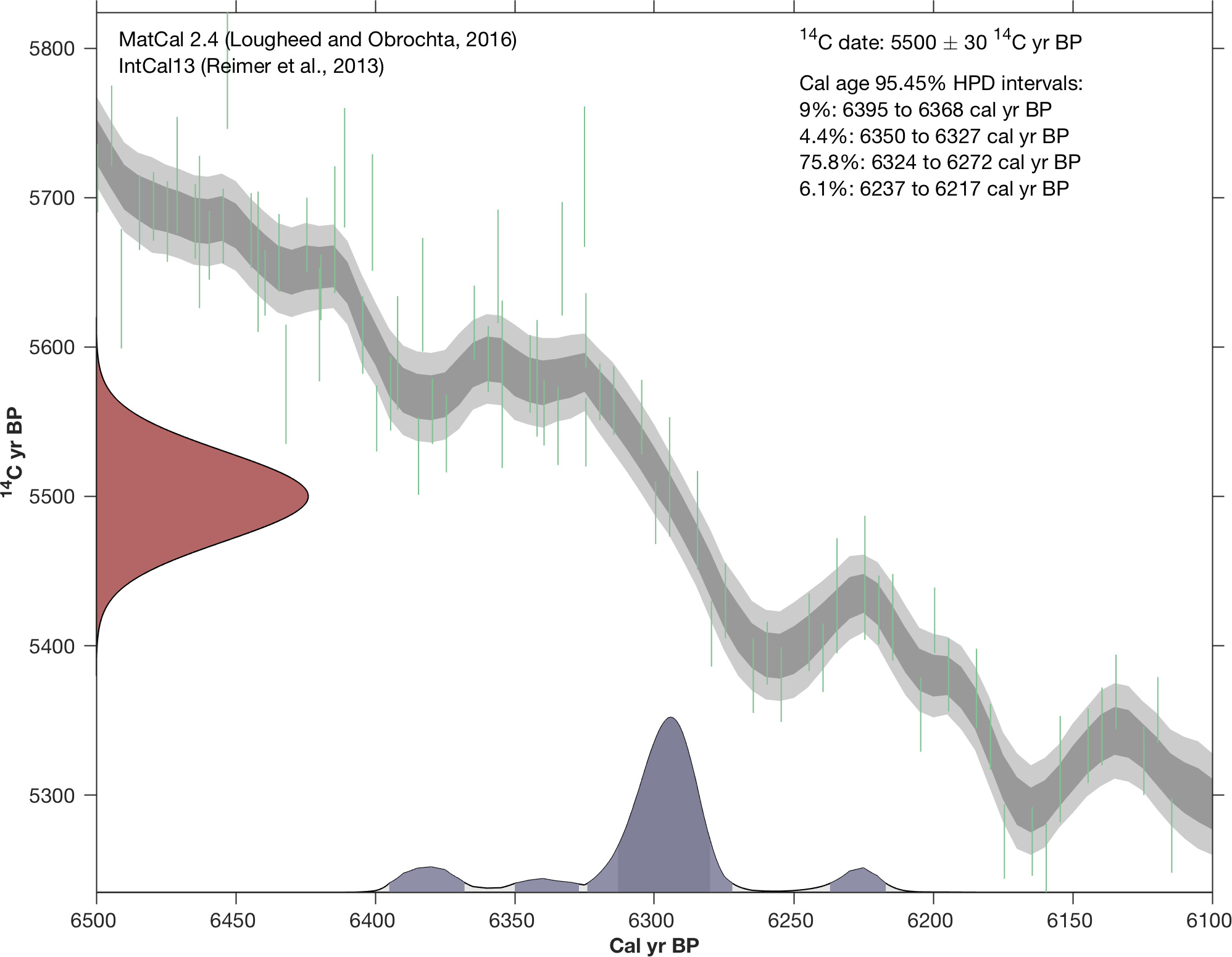 We developed Matcal, a function providing for radiocarbon (14C) age calibration in Matlab using Bayesian highest posterior density [HPD]. The function produces a probability distribution function (PDF) of calibrated ages, as well as 1 sigma (68.27%) and 2 sigma (95.45%) probability calibrated age intervals calculated using HPD. Publication-ready calibration plots are also produced, with the option to save to disk. Calibration output can be in either Cal BP or BCE/CE (BC/AD), and a reservoir age can be specified if necessary. The user can choose from a number of calibration curves, including the latest version of IntCal.
Lougheed, B.C., and Obrochta, S.P., 2016. MatCal: Open source Bayesian 14C age calibration in MatLab. Journal of Open Research Software 4(1). 10.5334/jors.130
Sea Level Change
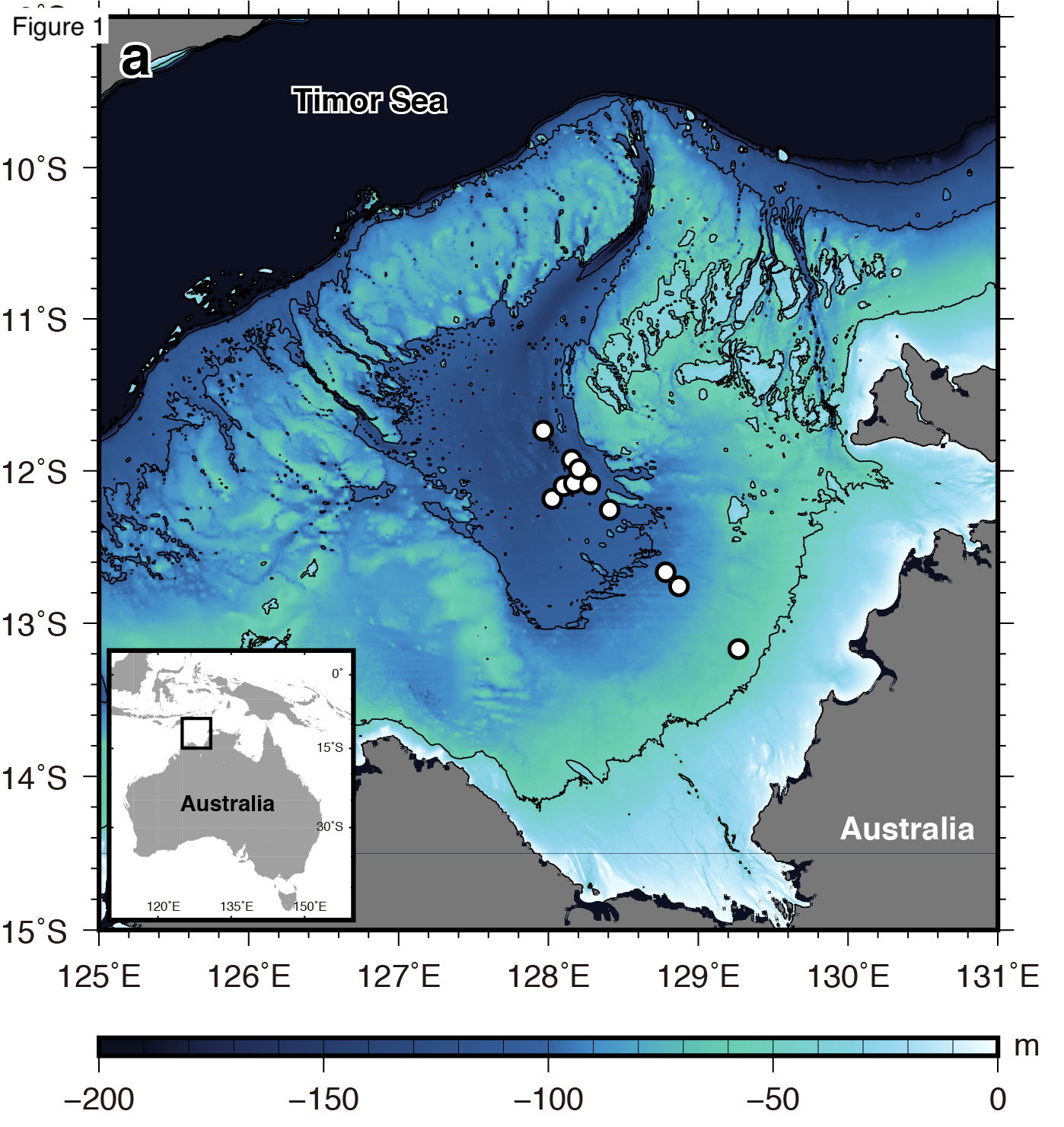 We are reconstructing sea level change from material obtained during Cruise KH11-1 to the Bonaparte Gulf, northwestern Australia. This is a so-called “far field” location because it is not proximal to large continental ice sheets, the mass of which depresses the surface of the earth, complicating reconstruction of eustatic sea level. From this work we first determined that the last glacial maximum was significantly shorter than previously thought. We then investigated the history of MIS 2 eustatic sea-level by reconstructing relative sea level and modeling glacial isostatic adjustment. The isostatically-corrected global sea-level history indicates that sea-level plateaued from 25.9 to 20.4 cal kyr BP (modeled median probability) prior reaching its minimum (19.7 to 19.1 cal kyr BP). Following the plateau, we detect a 10-m global sea-level fall over ~1,000 years and a short duration of the Last Glacial Maximum (global sea-level minimum; 19.7 to 19.1 cal kyr BP). These large changes in ice volume over such a short time indicates that the continental ice sheets never reached their isostatic equilibrium during the Last Glacial Maximum.
Ishiwa, T., Yokoyama, Y., Obrochta, S.P., Uehara, K., Okuno, J., Ikehara, M., and Miyairi, Y., 2021. Temporal variation in radiocarbon pathways caused by sea-level and tidal changes in the Bonaparte Gulf, northwestern Austral. Quaternary Science Reviews v. 266. 10.1016/j.quascirev.2021.107079
Ishiwa, T., Yokoyama, Y., Okuno, J., Obrochta, S.P., Uehara, K., Ikehara, M., and Miyairi, Y., 2019. A sea-level plateau preceding the Marine Isotope Stage 2 minima revealed by Australian sediments. Scientific Reports 9(1) 6449. 10.1038/s41598-019-42573-4
Ishiwa, T., Yokoyama, Y., Miyairi, Y., Ikehara, M., and Obrochta, S.P., 2016. Sedimentary environmental change induced from late Quaternary sea-level change in the Bonaparte Gulf, northwestern Australia. Geoscience Letters 3(1) 2–11. 10.1186/s40562-016-0065-0
Ishiwa, T., Yokoyama, Y., Miyairi, Y., Obrochta, S.P., Sasaki, T., Kitamura, A., Suzuki, A., Ikehara, M., Ikehara, K., Kimoto, K., Bourget, J., and Matsuzaki, H., 2016. Reappraisal of sea-level lowstand during the Last Glacial Maximum observed in the Bonaparte Gulf sediments, northwestern Australia. Quaternary International 397, 373–379. 10.1016/j.quaint.2015.03.032
Detecting and Correcting Non-Linear Sediment Deformation
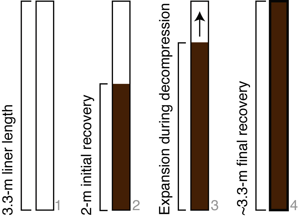 Laminated, organic-rich silts and clays with high dissolved gas content characterize sediments at IODP Site M0063 in the Landsort Deep, which at 459 m is the deepest basin in the Baltic Sea. Cores recovered from Hole M0063A experienced significant expansion as gas was released during the recovery process, resulting in high sediment loss. Therefore during operations at subsequent holes, penetration was reduced to 2 m per 3.3 m core, permitting expansion into 1.3 m of initially empty liner. Fully filled liners were recovered from Holes B through E, indicating that the length of recovered intervals exceeded the penetrated distance by a factor of >1.5. A typical down-core logarithmic trend in gamma density profiles, with anomalously low density values within the upper ~1 m of each core, suggests that expansion primarily occurred in this upper interval. Thus, we determined that a simple linear correction is inappropriate. This interpretation is supported by anisotropy of magnetic susceptibility data that indicate vertical stretching in the upper ~1.5 m of expanded cores. Based on the mean gamma density profiles of cores from Holes M0063C and D, we obtain an expansion function that is used to adjust the depth of each core to conform to its known penetration. The variance in these profiles allows for quantification of uncertainty in the adjusted depth scale. Using a number of bulk 14C dates, we explore how the presence of multiple carbon source pathways leads to poorly constrained radiocarbon reservoir age variability that significantly affects age and sedimentation rate calculations.
Obrochta, S.P., Andrén, T., Fazeka, S.Z., Lougheed, B. C., Snowball, I., yokoyama, Y., Miyairi, Y., Kondo, R., Kotilainen, A.T., Hyttinen, O., and Fehr, A., 2017. The undatables: Quantifying uncertainty in a highly expanded Late Glacial - Holocene sediment sequence recovered from the deepest Baltic Sea basin - IODP Site M0063. Geochemistry, Geophysics, Geosystems 18. 10.1002/2016GC006697
Related:
Snowball, I., Almqvist, B., Lougheed, B.C., Wiers, S., Obrochta, S.P., and Herrero-Bervera, E., 2019. Coring induced sediment fabrics at IODP Expedition 347 Sites M0061 and M0062 identified by anisotropy of magnetic susceptibility (AMS): criteria for accepting palaeomagnetic data. Geophysical Journal International 217(2) 1089–1107. 10.1093/gji/ggz075
Reconstructing Climate of the Past Several Hundred Years
 Understanding of the dynamical processes associated with and affected by ongoing global warming is hindered by the limited length of the observational records of modern climate. Therefore we are involved in work to extend these observations using proxy information gleamed from natural archives such as tree rings and annually-banded corals. This work has clarified that the recent hiatus, or pause, in global warming not at all unusual given the amplitude in natural climate variability.
In addition to the monsoon work underway at Lake Motosu, we have also been involved in using tree-ring cellulose identifying means for better understanding variations in climate phenomenon that directly impact precipitation amounts and patterns in Japan, such as the El Niño-Southern, Pacific Decadal Oscillation, and Baiu summer rains.
Crowley, T.J., Obrochta, S.P., and Liu, J., 2014. Recent global temperature “plateau” in the context of a new proxy reconstruction. Earth’s Future 2(5) 281–294.
Schurer, A.P., Hegrel, G.C., and Obrochta, S.P., 2015. Determining the likelihood of pauses and surges in global warming. Geophysical Research Letters 42(14) 5974–5982.
Sakashita, W., Yokoyama, Y., Miyahara, H., Yamaguchi, Y.T., Aze, T., Obrochta, S.P., and Nakatsuka, T., 2016. Relationship between early summer precipitation in Japan and the El Niño-Southern and Pacific Decadal Oscillations over the past 400 years. Quaternary International 397300–306.
Sakashita, W., Yokoyama, Y., Miyahara, H., Aze, T., Obrochta, S.P., Ohyama, M., and Yonenobu, H., 2018. Assessment of Northeastern Japan Tree-Ring Oxygen Isotopes for Reconstructing Early Summer Hydroclimate and Spring Arctic Oscillation. Geochemistry, Geophysics, Geosystems 19(9), 3520–3528. 10.1029/2018GC007634
Investigating the Penultimate Glaciation
 A composite North Atlantic record from DSDP Site 609 and IODP Site U1308 spans the past 300,000 years and shows that variability within the penultimate glaciation differed substantially from that of the surrounding two glaciations. Hematite stained grains exhibit similar repetitive down-core variations within the Marine Isotope Stage (MIS) 8 and 4–2 intervals, but little cyclic variability within the MIS 6 section. There is also no petrologic evidence, in terms of detrital carbonate-rich (Heinrich) layers, for surging of the Laurentide Ice Sheet through the Hudson Strait during MIS 6. Rather, very high background concentration of ice-rafted debris (IRD) indicates near continuous glacial meltwater input that likely increased thermohaline disruption sensitivity to relatively weak forcing events, such as expanded sea ice over deepwater formation sites. Altered (sub)tropical precipitation patterns and Antarctic warming during high orbital precession and low 65˚ N summer insolation appears related to high abundance of Icelandic glass shards and southward sea ice expansion. Differing European and North American ice sheet configurations, perhaps aided by larger variations in orbital eccentricity leading to cooler summers, may have contributed to the relative stability of the Laurentide Ice Sheet in the Hudson Strait region during MIS 6.
Obrochta, S.P., Crowley, T.J., Channell, J.E.T., Hodell, D.A., Baker, P.A., Seki, A., and Yokoyama, Y., 2014. Climate variability and ice-sheet dynamics during the last three glaciations. Earth and Planetary Science Letters 406(0) 198–212. 10.1016/j.epsl.2014.09.004
Understanding the So-Called "1500-year Cycle"
 Ice-rafting evidence for a "1500-year cycle" sparked considerable debate on millennial-scale climate change and the role of solar variability. Here, we reinterpret the last 70,000 years of the subpolar North Atlantic record, focusing on classic DSDP Site 609, in the context of newly available raw data, the latest radiocarbon calibration (Marine09) and ice core chronology (GICC05), and a wider range of statistical methodologies. A ~ 1500-year oscillation is primarily limited to the short glacial Stage 4, the age of which is derived solely from an ice flow model (ss09sea), subject to uncertainty, and offset most from the original chronology. Results from the most well-dated, younger interval suggest that the original 1500 ± 500 year cycle may actually be an admixture of the ~1000 and ~2000 cycles that are observed within the Holocene at multiple locations. In Holocene sections these variations are coherent with 14C and 10Be estimates of solar variability. Our new results suggest that the "1500 year cycle" appears to be a transient phenomenon whose origin could be due to ice sheet boundary conditions for the interval in which it is observed. We therefore question whether it is necessary to invoke exotic explanations such as heterodyne frequencies or combination tones to explain a phenomenon of such fleeting occurrence that is potentially an artifact of arithmetic averaging.
Obrochta, S.P., Miyahara, H., Yokoyama, Y., and Crowley, T.J., 2012. A re-examination of evidence for the North Atlantic “1500-year cycle” at Site 609. Quaternary Science Reviews 55, 23–33.
Obrochta, S.P., Yokoyama, Y., Morén, J., and Crowley, T.J., 2014. Conversion of GISP2-based sediment core age models to the GICC05 extended chronology. Quaternary Geochronology 20(0) 1–7.
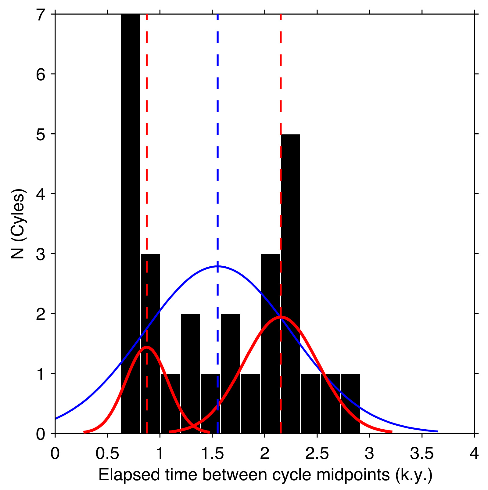
Onset of Dansgaard-Oescher Events
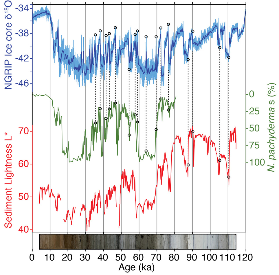 Scientific drilling has been widely conducted in the North Atlantic Ocean. One site in particular, DSDP Site 609, has attracted much attention because the records closely resemble the Greenland ice core record. However, continuous data from DSDP 609 are limited to the approximately the past 100,000 years. Therefore, additional sediment cores were recovered from the same location. The newer Site U1308 now extending the original record beyond 3 million years before present. This provides an opportunity to explore the timing of Dansgaard-Oescher Event onset using CoreLab to construct a high-resolution record of DO Events with minimal post-depositional color artifacts.